
Corvo is the smallest and northernmost inhabited island of the Azores archipelago, located in the North Atlantic Ocean. Known for its dramatic volcanic landscapes and lush greenery, the island is dominated by the Caldeirão, a massive volcanic crater with steep cliffs and small lakes inside.

The airport on Corvo Island features a single short runway, reflecting the island’s tiny size and rugged terrain. Surrounded by green volcanic hills and steep cliffs, the runway offers spectacular, yet challenging, approach and departure conditions for pilots, with strong winds and changing weather requiring careful navigation.

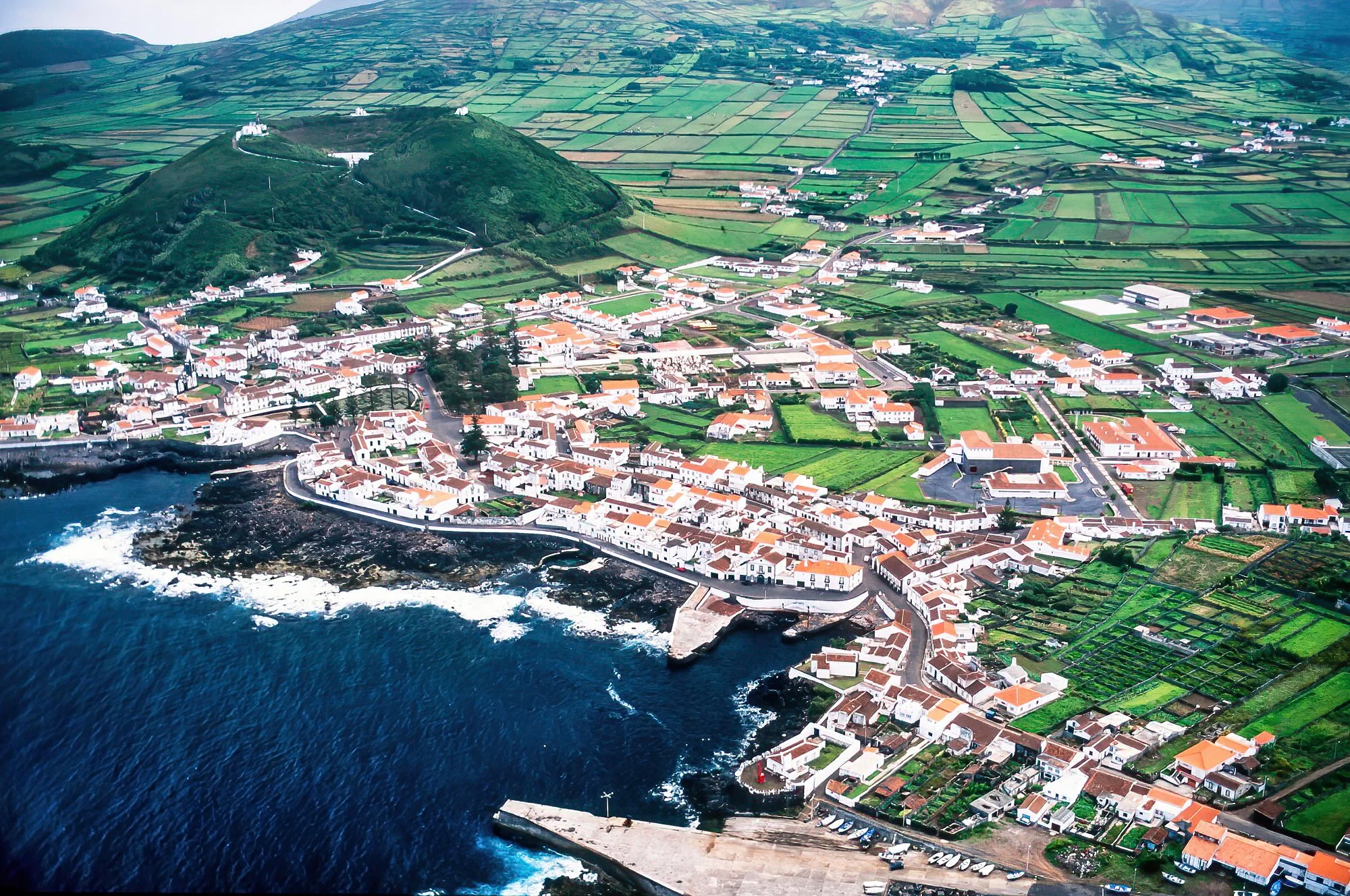
Faial Island is known for its striking volcanic landscapes, lush vegetation, and maritime heritage.

On Faial Island the feature sometimes called Caldeira do Inferno refers to the twin volcanic craters known as Caldeirinhas, located on Monte da Guia near Horta and Porto Pim Bay. These interconnected craters are partially flooded by the sea, forming a distinctive figure‑eight shape and creating a unique coastal volcanic landscape.

Flores Island is a remote and verdant island known for its dramatic landscapes, Flores is dotted with waterfalls, volcanic craters, lakes, and lush greenery, earning it the nickname “Island of Flowers.”

The island’s coastline is rugged, with steep cliffs and hidden coves that meet the Atlantic, while its interior features caldeiras and freshwater lakes such as Lagoa Funda and Lagoa Comprida.
Graciosa Island is a small, serene island known for its gentle landscapes, volcanic features, and traditional charm. The island is largely agricultural, with rolling green fields, vineyards, and windmills dotting the terrain.

On Graciosa Island there is a remarkable site often referred to as the “bullring inside a volcano”, which is actually the Furna do Enxofre or a nearby volcanic crater adapted for local festivities.

Pico Island is part of the Azores archipelago and is dominated by Mount Pico, Portugal’s highest peak at 2,351 meters (7,713 feet). Pico is also famous for its vineyards, a UNESCO World Heritage Site, where vines are grown in black volcanic rock walls called currais, producing the island’s distinctive wine.

Mount Pico is the towering volcanic peak that dominates Pico Island. This stratovolcano is characterized by its conical shape, steep slopes, and rugged lava fields that stretch down toward the coastline.

The summit is often shrouded in clouds, adding to its dramatic presence, and provides panoramic views of neighboring islands and the Atlantic Ocean. Mount Pico is an active volcano, though its last eruption was in 1718, and its slopes are covered with both barren lava landscapes and lush vegetation at lower elevations.

The island is renowned for its dramatic volcanic landscapes, including lava fields, craters, and caves.

On Santa Maria Island agriculture has traditionally been a cornerstone of local life, taking advantage of the island’s fertile volcanic soils and mild climate. The landscape is dotted with small farms, pasturelands, and terraced fields, where crops such as corn, potatoes, and vegetables are cultivated.

The Farol de Gonçalo Velho is the main lighthouse on Santa Maria Island in the Azores. Perched along the island’s coastline, it serves as a crucial navigational aid for vessels traversing the Atlantic.

São Jorge Island is part of the Central Group of the Azores archipelago, known for its dramatic cliffs, lush greenery, and distinctive fajãs—flat, fertile coastal plains formed by lava flows or landslides. São Jorge is famous for its dairy farming and cheese production, particularly the creamy São Jorge cheese.

São Jorge Island is home to a few coastal lighthouses that guide ships along its rugged cliffs. This lighthouse sits atop steep cliffs, overlooking the Atlantic Ocean, and is designed to help vessels navigate the island’s treacherous coastal waters.

São Miguel Island is the largest and most populous island of the Azores archipelago, often called the “Green Island” due to its lush landscapes, volcanic lakes, and rolling hills.

The landscape is characterized by green pastures, terraced fields, and patchwork farmland. This agricultural landscape is a key part of the island’s identity and sustains both the local economy and traditional Azorean culture.

The Ilhéus das Cabras are two small, rugged volcanic islets located just off the southern coast of Terceira Island, in the Azores, near Angra do Heroísmo.
Seen here is a Puma helicopter, these have long played a vital role in the Azores, where rugged islands and vast ocean distances demand reliable air support. With their powerful engines and long range, Puma helicopters are well suited to the Azores’ challenging weather and open Atlantic conditions.

Angra do Heroísmo, on Terceira Island in the Azores, is a historic coastal city known for its colorful architecture, natural harbor, and rich maritime past. Founded in the 15th century, it once served as a key Atlantic port and is now recognized as a UNESCO World Heritage Site, valued for its well-preserved streets, churches, and forts set against a backdrop of volcanic hills and the sea.

Terceira is a vibrant island in the Azores, known for its volcanic landscapes, green pastures, and rich cultural traditions. The island features rolling hills, lava fields, and underground volcanic caves, alongside fertile farmland that supports dairy cattle and traditional agriculture.

Its main city, Angra do Heroísmo, is a UNESCO World Heritage Site, celebrated for its historic streets, churches, and natural harbor. Terceira is also famous for its lively festivals, including traditional bull-running events, and for its strong community spirit. Blending natural beauty with history and culture, Terceira offers a distinctive and authentic Azorean experience.

Terceira Island is dotted with historic forts built to protect the island from pirates and foreign invaders during the 16th–18th centuries. The most famous is the Fort of São João Baptista, a volcanic peninsula overlooking the city of Angra do Heroísmo. This massive star-shaped fortress features thick stone walls, bastions, and cannons, designed to withstand attacks from the sea.

The Ilhéus das Cabras are two small, rugged volcanic islets located just off the southern coast of Terceira Island in the Azores. Rising steeply from the Atlantic Ocean, these uninhabited islets are made of dark volcanic rock and are largely inaccessible, providing a dramatic contrast to Terceira’s green landscapes.

The Ilhéus das Cabras, off the coast of Terceira Island in the Azores, are small, rugged volcanic islets. Traditionally, these islets were used for grazing sheep, taking advantage of their natural vegetation and isolation. The sheep thrived in this remote environment, feeding on the sparse grass and shrubs, and the location helped prevent predators from reaching the flock.